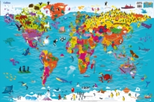
Image for Collins Children's World Map

Collins Children's World Map

Collins MapsEvans, Steve(Illustrated by)
See all formats and editions

Colourful Illustrated Map of the World This highly illustrated pictorial map is designed to take children on a journey of discovery around the countries of the world.

The mapping is clear, colourful and highly informative and shows countries and capital cities. Stunning illustrations are used to depict themes such as national emblems, customs, food, birds, animals, buildings and sports to help younger readers gain an understanding of peoples around the world. Dimensions 610 X 915 mm Illustrated by Steve Evans.

Read More
Title Unavailable: Out of Print
Product Details
Collins
0008114730 / 9780008114732
Sheet map, rolled
912
23/04/2015
United Kingdom
900 x 600 mm, 40 grams
Children / Juvenile Learn More